Spotting flooding areas around the home
EXPLORATION & KNOWLEDGE SHARING
The method involves the use of basic geographical knowledge to locate the river and the riparian areas with potential exposure to overflowing waters.
Short summary of the practice
This practice is intended for residents of flood risk areas. The method involves the use of basic geographical knowledge to locate the river and the riparian areas with potential exposure to overflowing waters.
Goal of the practice
Inform and alert flood risk areas.
Target group
This practice is directly addressed to pupils and students who have classes related to hydrological risks in their curriculum, but secondly, it can be used (with a little training) by any member of a riparian community affected by floods. All that needs to be known is a little about the use of mapping applications and users to be creative and patient so that they can explore the features of the City Skylines game. From this point of view, the key users would be the young people, who possess such knowledge and are more computer and internet-skills. They could take the information from the residents (the level at which the water reached in the houses, in the households, data about the damaged infrastructure elements) and then enter them in the appropriate format in the game and do the simulation.
Number of participants: Unlimited
Age of participants: Youth or adults, Students, 18+
Materials
- Phone
- Internet access
Method Settings
It can be used in areas exposed to river floods.
Duration
It can take 1 or 2 days.

Preparation
Need some preparation for finding an areas exposed to river floods
Step by step guide
Before trying this practice, users must own some minimal geographical knowledge or at least have a more developed sense of observation and spatial orientation.
In the first place, this practice is used when the hydrological risks are known for a locality or an area adjacent to a river. In other words, if there is already a history of these risk events. If not, it can still be used, but the results and their analysis will be at a hypothetical level.
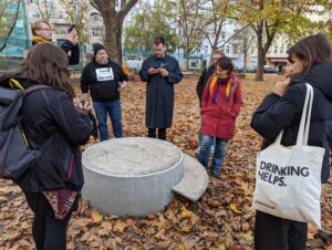
In step 2, the users of the exercise have to go out into the field (so it has to be accessible) and observe, as best they can, what the river looks like or what potential elements would be at risk. For example, agricultural land, houses near the river, in the floodplain, dikes, bridges, other infrastructure elements, riparian vegetation. Furthermore, at this stage, these elements can be mapped using a mobile application (e.g. QField, recommended in the game instructions). Optionally, and to the extent that they can be observed, witnesses of the flood can also be registered. This stage additionally trains and educates the user to be aware of the effects of the hydrological risk. E.g. eroded banks, damaged houses or land from the last floods, waste such as PETs or fabrics hanging on the branches of the woody vegetation along the river. These factors translate the level reached by the river in the previous phases of flooding.
In step 3, the mapped spatial information is downloaded (there is no minimum number or certain fixed categories) in a format compatible with GIS systems.
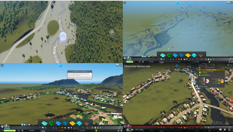
In step 4, the functions of the City Skylines game are used to represent the natural and anthropogenic elements in the targeted area, based on a map support compatible with the game. Finally, the mapped elements are added to the map. The flood behaviour is simulated by adding various elements from the game library (i.e. rain or water sources such as water buckets, dams, natural and anthropogenic elements from the river environment). As the accuracy of the spatial representation is not high, the exercise can not be used for decision-making at the administrative level. However, it can be an excellent tool to educate the riverine population and increase their awareness (through the game and training of their spatial skills) of the hydrological risks in the area / their locality.
Expected output
Identify new flood risks in the area.
DOs, DONTs and ethical considerations of the method
DOs of the method:
- Do list the areas at risk.
DONTs of the method:
- Avoid adding useless or false reports.
Change the method brings to the communities
From a student’s perspective, numbers are not enough for us to understand the river’s behaviour. A game-based approach is more suitable in order to facilitate a better visual understanding. By simulating a flood in the City SkyLines computer game, we can more easily recognize this phenomenon in real life. Therefore, this method links the theoretical part to the practical part, which is essential for any geographer. We created in the game the city of Novaci, trying to make the relief as realistic as possible. By simulating the water (we could not represent the exact amount of water) we tried to: understand what would happen during a major flood event what would be the consequences where anthropological arrangements can be made to protect the population.
Adaptation/Application of the method
The method can be adapted to any city.
Credit, References, and Resources
Currently, there is no link to the tool, but there is a link to the game – https://store.epicgames.com/en-US/p/cities-skylines.
The ArcGIS Story Map published about a simulation case on the Gilort River (Romania), work from 19 July 2022 – https://storymaps.arcgis.com/stories/7c2a2595d2014d478fc2c0ff4f7621f9
Related posts

Active Citizenship
Active citizenship in this context refers to the power of individuals or small resident groups to proactively engage in community mapping exercises for improving their city or neighborhood.

ArcGIS Online
ArcGIS Online provides a cloud-based mapping and analysis solution. It is used to create interactive web maps, analyse data, share and collaborate.

Civic Alert
Civic Alert is a platform designed to facilitate communication between citizens and governments. Citizens can use their mobile application to report problems in the city to the authorities in three easy steps.
